DSpace CRIS
DSpace-CRIS consists of a data model describing objects of interest to Research and Development and a set of tools to manage the data. Standard DSpace is used to deal with publications and data sets, whereas DSpace-CRIS involves other CRIS entities: Researcher Pages, Projects, Organization Units and Second Level Dynamic Objects (single entities specialized by a profile, such as Journal, Prize, Event etc; because any profile can define its own set of properties and nested objects)
Learn MorePlease use this identifier to cite or link to this item:
https://hdl.handle.net/10316.2/43225| Title: | Das Königreich Portugal | Keywords: | Portugal;Mapa | Issue Date: | 1868 | Publisher: | Stich, Druck und Verlag Bibliographischen Instituts zu Hildbrughausen | Description: | Contém pequenos mapas detalhados de : Lisboa; Porto; Açores, Madeira, Cabo Verde e São Tomé. Retirado de Meyers Hand-Atlas. Escala gráfica: 20 Deutsche geograph. Meilen 15 =1 Aequ. Gr.; 25 Neue Spanische Leguas 17 2/3 = 1 Aequ. Gr.; 25 Portugiesische Legoas 17,93 = 1 Aequ. Gr. |
URI: | https://hdl.handle.net/10316.2/43225 | Rights: | open access |
| Appears in Collections: | Cartografia |
Files in This Item:
| File | Description | Size | Format | |
|---|---|---|---|---|
| UCBG-NC-0363_0001_1_t0.tif | 79.27 MB | TIFF | 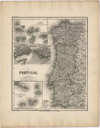 |
This item is licensed under a Creative Commons License
