DSpace CRIS
DSpace-CRIS consists of a data model describing objects of interest to Research and Development and a set of tools to manage the data. Standard DSpace is used to deal with publications and data sets, whereas DSpace-CRIS involves other CRIS entities: Researcher Pages, Projects, Organization Units and Second Level Dynamic Objects (single entities specialized by a profile, such as Journal, Prize, Event etc; because any profile can define its own set of properties and nested objects)
Learn MorePlease use this identifier to cite or link to this item:
https://hdl.handle.net/10316.2/43257| Title: | France West Coast Sheet III : Pte. de la Coubre to les Sables d'Olonne : from the French Government Charts to 1940 | Keywords: | França;Costa Ocidental;Mapa | Issue Date: | 1944 | Publisher: | Published at the Admiralty | Description: | Encarte: "Port of Les Sables d'Olonne" com a escala 1:25 000. | URI: | https://hdl.handle.net/10316.2/43257 | Rights: | open access |
| Appears in Collections: | Cartografia |
Files in This Item:
| File | Description | Size | Format | |
|---|---|---|---|---|
| UCBG-NC-0487_0001_1_t0.tif | 300.62 MB | TIFF | 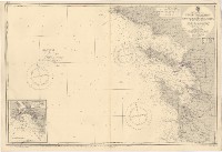 |
This item is licensed under a Creative Commons License
