DSpace CRIS
DSpace-CRIS consists of a data model describing objects of interest to Research and Development and a set of tools to manage the data. Standard DSpace is used to deal with publications and data sets, whereas DSpace-CRIS involves other CRIS entities: Researcher Pages, Projects, Organization Units and Second Level Dynamic Objects (single entities specialized by a profile, such as Journal, Prize, Event etc; because any profile can define its own set of properties and nested objects)
Learn MorePlease use this identifier to cite or link to this item:
https://hdl.handle.net/10316.2/43266| Title: | Mediterranean : Africa : C. Tres Forcas to C. Ivi : surveyed by Captain E. Mouchez of the french Navy 1870-73 | Keywords: | Argélia;Marrocos;Mar Mediterrâneo;Mapa | Issue Date: | 1952 | Publisher: | published at the Admiralty | Description: | Encartes: Islas Chafarinas, escala 1:25 000 projection gnomonic ; Puerto de Melilla, escala 1:15 000 projection gnomonic. | URI: | https://hdl.handle.net/10316.2/43266 | Rights: | open access |
| Appears in Collections: | Cartografia |
Files in This Item:
| File | Description | Size | Format | |
|---|---|---|---|---|
| UCBG-NC-0452_0001_1_t0.tif | 329.73 MB | TIFF | 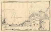 |
This item is licensed under a Creative Commons License
