DSpace CRIS
DSpace-CRIS consists of a data model describing objects of interest to Research and Development and a set of tools to manage the data. Standard DSpace is used to deal with publications and data sets, whereas DSpace-CRIS involves other CRIS entities: Researcher Pages, Projects, Organization Units and Second Level Dynamic Objects (single entities specialized by a profile, such as Journal, Prize, Event etc; because any profile can define its own set of properties and nested objects)
Learn MorePlease use this identifier to cite or link to this item:
https://hdl.handle.net/10316.2/43269| Title: | Mediterranean Sea : Europe Gibraltar to Alicante : Africa Cape Spartel to Cape Ferrat : from spanish and french government charts to 1877 | Keywords: | Sul de Espanha;Marrocos;Mar Mediterrâneo;Mapa | Issue Date: | 1910 | Publisher: | published at the Admiralty | Description: | Encartes: Salobreña Anch.ge, Cala Honda, Ferro Castle Anch.ge, Puerto de Adra, Almeria Road, Cape de Gata, Port Genovés, S. Pedro Bay, Carboneras Bay, Port Aguilas, Cape Anchorage, Mazarron and Azohia Bays, Porman Bays, Escullas Bay, Nerja Anch.ge. Herradura Bay, Berenguelles Bay. | URI: | https://hdl.handle.net/10316.2/43269 | Rights: | open access |
| Appears in Collections: | Teste - Nabais Conde reprocessados |
Files in This Item:
| File | Description | Size | Format | |
|---|---|---|---|---|
| UCBG-NC-0451_0001_1_t0.tif | 300.87 MB | TIFF | 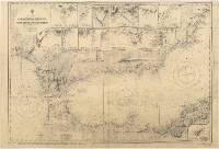 |
This item is licensed under a Creative Commons License
