DSpace CRIS
DSpace-CRIS consists of a data model describing objects of interest to Research and Development and a set of tools to manage the data. Standard DSpace is used to deal with publications and data sets, whereas DSpace-CRIS involves other CRIS entities: Researcher Pages, Projects, Organization Units and Second Level Dynamic Objects (single entities specialized by a profile, such as Journal, Prize, Event etc; because any profile can define its own set of properties and nested objects)
Learn MorePlease use this identifier to cite or link to this item:
https://hdl.handle.net/10316.2/43343| Title: | Africa : Sheet IV : from Hollams Island to Cape Corrientes including the Cape of Good Hope | Keywords: | África;Oceano Índico;Costa;Mapa;Carta náutica | Issue Date: | 1827 | Publisher: | Hydrographical Office of the Admiralty | Description: | Contém vista de St. Helena Bay to Table Bay. | URI: | https://hdl.handle.net/10316.2/43343 | Rights: | open access |
| Appears in Collections: | Cartografia |
Files in This Item:
| File | Description | Size | Format | |
|---|---|---|---|---|
| UCBG-NC-0432_0001_1_t0.tif | 282.62 MB | TIFF | 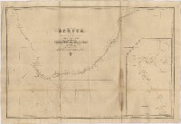 |
This item is licensed under a Creative Commons License
