DSpace CRIS
DSpace-CRIS consists of a data model describing objects of interest to Research and Development and a set of tools to manage the data. Standard DSpace is used to deal with publications and data sets, whereas DSpace-CRIS involves other CRIS entities: Researcher Pages, Projects, Organization Units and Second Level Dynamic Objects (single entities specialized by a profile, such as Journal, Prize, Event etc; because any profile can define its own set of properties and nested objects)
Learn MorePlease use this identifier to cite or link to this item:
https://hdl.handle.net/10316.2/43362| Title: | A chart of the sea coasts of Algrave [sic] and Andalusia between cape St. Vincent and the strait of Gibralter and c. Spartel | Keywords: | Algarve;Andaluzia;Cádiz;Costa;Baía | Issue Date: | 1758 | Publisher: | W. Mount e T. Page | Description: | Margem superior à direita contém mapa da Baía de Cádiz. Escala gráfica: 16 English an d French leagues 20 in a degree |
URI: | https://hdl.handle.net/10316.2/43362 | Rights: | open access |
| Appears in Collections: | Cartografia |
Files in This Item:
| File | Description | Size | Format | |
|---|---|---|---|---|
| UCBG-NC-0570_0001_1_t0.tif | 116.2 MB | TIFF | 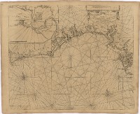 |
This item is licensed under a Creative Commons License
