DSpace CRIS
DSpace-CRIS consists of a data model describing objects of interest to Research and Development and a set of tools to manage the data. Standard DSpace is used to deal with publications and data sets, whereas DSpace-CRIS involves other CRIS entities: Researcher Pages, Projects, Organization Units and Second Level Dynamic Objects (single entities specialized by a profile, such as Journal, Prize, Event etc; because any profile can define its own set of properties and nested objects)
Learn MorePlease use this identifier to cite or link to this item:
https://hdl.handle.net/10316.2/43364| Title: | Nieuwe Pascaert van alle de Vlaemse Eylanden : Met hinne diepten en drooghten, Waer in oock te sien is hoe haer de Kust vertoont uyter zee sÿnde noÿt voor desen soo int Licht geweest | Keywords: | Açores;Oceano Atlântico;Costa;Mapa;Carta náutica | Issue Date: | 1670 | Publisher: | Iohannis van Keule | Description: | Margem superior ao centro: cartela de tit. ornamentada com figuras de anjos. Na margem superior apresenta de ambos os lados pequenos mapas da Ilha do Faial e da cidade de Angra do Heroísmo. Margem inferior à esquerda: cartela com escala ornamentada com figuras de anjos. Na margem inferior direita apresenta pequeno mapa da Ilha de São Miguel. Encontra-se também impresso o n{u00BA} "34". Escala gráfica: Duistsche Mylen 15 in een Graadt ; Eng: en Fran. Mylen 20 in een Graadt ; Spaensche Mylen 17 1/2 in een Graad |
URI: | https://hdl.handle.net/10316.2/43364 | Rights: | open access |
| Appears in Collections: | Cartografia |
Files in This Item:
| File | Description | Size | Format | |
|---|---|---|---|---|
| UCBG-NC-0567_0001_1_t0.tif | 548.93 MB | TIFF | 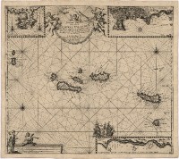 |
This item is licensed under a Creative Commons License
