DSpace CRIS
DSpace-CRIS consists of a data model describing objects of interest to Research and Development and a set of tools to manage the data. Standard DSpace is used to deal with publications and data sets, whereas DSpace-CRIS involves other CRIS entities: Researcher Pages, Projects, Organization Units and Second Level Dynamic Objects (single entities specialized by a profile, such as Journal, Prize, Event etc; because any profile can define its own set of properties and nested objects)
Learn MorePlease use this identifier to cite or link to this item:
https://hdl.handle.net/10316.2/43369| Title: | Portuguese Islands in the Atlantic Ocean | Keywords: | Açores;Madeira;Mapa | Issue Date: | 1865 | Publisher: | A. Fullarton and Co. | Description: | Mapa publicado em: "The Royal Illustrated Atlas of Modern Geography". Ornamentado com motivos da fauna e flora locais e com imagens de figuras típicas. Apresenta duas vistas: Ilha do Faial vista do Pico e Cidade do Funchal. |
URI: | https://hdl.handle.net/10316.2/43369 | Rights: | open access |
| Appears in Collections: | Cartografia |
Files in This Item:
| File | Description | Size | Format | |
|---|---|---|---|---|
| UCBG-NC-0559_0001_1_t0.tif | 63.26 MB | TIFF | 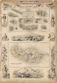 |
This item is licensed under a Creative Commons License
