DSpace CRIS
DSpace-CRIS consists of a data model describing objects of interest to Research and Development and a set of tools to manage the data. Standard DSpace is used to deal with publications and data sets, whereas DSpace-CRIS involves other CRIS entities: Researcher Pages, Projects, Organization Units and Second Level Dynamic Objects (single entities specialized by a profile, such as Journal, Prize, Event etc; because any profile can define its own set of properties and nested objects)
Learn MorePlease use this identifier to cite or link to this item:
https://hdl.handle.net/10316.2/43381| DC Field | Value | Language |
|---|---|---|
| dc.coverage.spatial | [c. 1:1 200 000] | - |
| dc.date.accessioned | 2019-07-30T09:55:55Z | - |
| dc.date.available | 2019-07-30T09:55:55Z | - |
| dc.date.issued | 1787 | - |
| dc.identifier.uri | https://hdl.handle.net/10316.2/43381 | - |
| dc.description | Cartela de tit. ornamentada com motivos florais e coroada com escudos dos Reinos de Portugal e Algarve. | - |
| dc.description | Representação da divisão administrativa e indicação numérica dos valores das cotas de profundidade ao longo de toda a costa marítima. | - |
| dc.description | Escala gráfica: 15 Common Leagues of Portugal 18 to a Degree ; 15 Sea Leagues 20 to a Degree ; 50 British Miles 69 1/2 to a Degree | - |
| dc.format.extent | 1 mapa : color. ; 61x43 cm | - |
| dc.format.mimetype | application/pdf | - |
| dc.format.mimetype | image/tiff | - |
| dc.language.iso | eng | - |
| dc.publisher | Printed for Rob.T Sayer, Map e Printseller, N{u00BA} 53 Fleet Street | - |
| dc.rights | open access | - |
| dc.rights.uri | https://creativecommons.org/licenses/by/4.0 | - |
| dc.subject | Portugal | - |
| dc.subject | Mapa | - |
| dc.title | The Kingdoms of Portugal and Algarve from Zannonïs Map | eng |
| dc.type | map | - |
| uc.publication.location | Londres | - |
| uc.publication.digCollection | BG | - |
| uc.publication.digCollection | NC | - |
| uc.publication.digLibrary | ucbg | - |
| uc.publication.manifest | https://dl.uc.pt/json/iiif/10316.2/43381/106262/manifest?manifest=/json/iiif/10316.2/43381/106262/manifest | - |
| uc.publication.thumbnail | https://dl.uc.pt/retrieve/5684690 | - |
| uc.publication.copynote | Material frágil, acesso sob autorização. | - |
| uc.publication.callnumber | NC-586 | - |
| uc.publication.siib | b2706958 | - |
| uc.publication.images | 2 | |
| uc.publication.publisher | London : Printed for Rob.T Sayer, Map !e! Printseller, N{u00BA} 53 Fleet Street, Published as the Act directs 2nd March 1787 | - |
| dc.subject.udc | 912 (469) "17" | - |
| uc.publication.subject | Portugal -- mapa -- 1787 | - |
| dc.contributor.engraver | Lodge, John | - |
| dc.contributor.cartographer | Rizzi-Zannoni,Giovanni Antonio | - |
| uc.contributor.engraverView | Lodge, John, fl.1755-1796 | - |
| uc.publication.date | Published as the Act directs 2nd March 1787 | - |
| uc.contributor.cartographerView | Rizzi-Zannoni,Giovanni Antonio, 1736-1814 | - |
| uc.itemId | 44644 | - |
| uc.thumbnail.uri | https://dl.uc.pt/iiif-imgsrv/5684547/dl!4!UC!BG!-N!UCBG-NC-0586_0001_1_t0.tif | - |
| item.grantfulltext | open | - |
| item.fulltext | With Fulltext | - |
| Appears in Collections: | Cartografia | |
Files in This Item:
| File | Description | Size | Format | |
|---|---|---|---|---|
| UCBG-NC-0586_0001_1_t0.tif | 171.87 MB | TIFF | 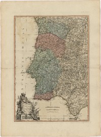 |
This item is licensed under a Creative Commons License
