DSpace CRIS
DSpace-CRIS consists of a data model describing objects of interest to Research and Development and a set of tools to manage the data. Standard DSpace is used to deal with publications and data sets, whereas DSpace-CRIS involves other CRIS entities: Researcher Pages, Projects, Organization Units and Second Level Dynamic Objects (single entities specialized by a profile, such as Journal, Prize, Event etc; because any profile can define its own set of properties and nested objects)
Learn MorePlease use this identifier to cite or link to this item:
https://hdl.handle.net/10316.2/43390| Title: | Pas-caart van Hispangien : vertoonende de Custen van Granade, Andaluzie, Algarve Portugael, Galissien, en Biscaien, met een gedeelte van Vranckrÿck : streckende van Hey sant tot de Straet van Gibralter | Keywords: | Peninsula Ibérica;Mapa | Issue Date: | 1669 | Publisher: | by Pieter Goos op't Water bÿ de N:brugh. in De Vergulde Zee-Spiegel | Description: | Cartela do tít. rodeada por dois homens, uma com mapa na mão e outra astrolábio e encimada por um escudo e coroa; no canto superior esquerdo tem o escudo de França. Escala gráfica: Duytsche Mylen 15 voor een graadt, spaensche Mylen 17 1/2 voor een graadt, Engelf en Frans Mylen 20 in een graadt. |
URI: | https://hdl.handle.net/10316.2/43390 | Rights: | open access |
| Appears in Collections: | Cartografia |
Files in This Item:
| File | Description | Size | Format | |
|---|---|---|---|---|
| UCBG-NC-0631_0001_1_t0.tif | 125.27 MB | TIFF | 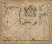 |
This item is licensed under a Creative Commons License
