DSpace CRIS
DSpace-CRIS consists of a data model describing objects of interest to Research and Development and a set of tools to manage the data. Standard DSpace is used to deal with publications and data sets, whereas DSpace-CRIS involves other CRIS entities: Researcher Pages, Projects, Organization Units and Second Level Dynamic Objects (single entities specialized by a profile, such as Journal, Prize, Event etc; because any profile can define its own set of properties and nested objects)
Learn MorePlease use this identifier to cite or link to this item:
https://hdl.handle.net/10316.2/43411| Title: | A new and correct chart of the coast of Portugal from Cape Stan to Cape Montego ; A new and correct chart of the coast of Portugal from Cape Montego to Pont de Faro | Keywords: | Portugal;Costa | Issue Date: | 1764 | Publisher: | [Mount e Page] | Description: | Dados referentes a escala e publicação retirados de registo existente na Biblioteca Nacional de Portugal. Publicado em: A complete set of new charts on thirty-eight large plates containing an accurate survey of the coast of Portugal and the Mediterranean sea in which are included seventy-five charts / Giacomo Alagna of Messina. Escala gráfica: 8 French leagues 20 to a degree : 6 Dutch leagues 15 to a degree ; 7 Spanish leagues 17 1/2 to a degree. |
URI: | https://hdl.handle.net/10316.2/43411 | Rights: | open access |
| Appears in Collections: | Cartografia |
Files in This Item:
| File | Description | Size | Format | |
|---|---|---|---|---|
| UCBG-NC-0709_0001_1_t0.tif | 213.3 MB | TIFF | 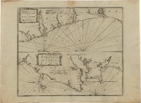 |
This item is licensed under a Creative Commons License
