DSpace CRIS
DSpace-CRIS consists of a data model describing objects of interest to Research and Development and a set of tools to manage the data. Standard DSpace is used to deal with publications and data sets, whereas DSpace-CRIS involves other CRIS entities: Researcher Pages, Projects, Organization Units and Second Level Dynamic Objects (single entities specialized by a profile, such as Journal, Prize, Event etc; because any profile can define its own set of properties and nested objects)
Learn MorePlease use this identifier to cite or link to this item:
https://hdl.handle.net/10316.2/43564| DC Field | Value | Language |
|---|---|---|
| dc.coverage.spatial | Escala não determinada | - |
| dc.date.accessioned | 2019-07-30T13:40:11Z | - |
| dc.date.available | 2019-07-30T13:40:11Z | - |
| dc.date.issued | 1534 | - |
| dc.identifier.uri | https://hdl.handle.net/10316.2/43564 | - |
| dc.format.extent | 1 mapa : p&b ; 8x15 cm | - |
| dc.format.mimetype | application/pdf | - |
| dc.format.mimetype | image/tiff | - |
| dc.language.iso | lat | - |
| dc.publisher | [s.n.] | - |
| dc.relation.isreferencedby | Olhar o mundo, ler o território, p. 218 | - |
| dc.rights | open access | - |
| dc.rights.uri | https://creativecommons.org/licenses/by/4.0 | - |
| dc.subject | Ilha de Porto Santo | - |
| dc.title | [Isolario] : porto santo | lat |
| dc.type | map | - |
| uc.publication.location | Veneza | - |
| uc.publication.digCollection | BG | - |
| uc.publication.digCollection | NC | - |
| uc.publication.digLibrary | ucbg | - |
| uc.publication.manifest | https://dl.uc.pt/json/iiif/10316.2/43564/106801/manifest?manifest=/json/iiif/10316.2/43564/106801/manifest | - |
| uc.publication.thumbnail | https://dl.uc.pt/retrieve/5686447 | - |
| uc.publication.callnumber | NC-942 | - |
| uc.publication.siib | b2714048 | - |
| uc.publication.images | 2 | |
| uc.publication.publisher | [Venice] : [s.n.], [c. 1550] | - |
| dc.subject.udc | 912 (469.8) "15" | - |
| uc.publication.subject | Porto Santo -- mapa -- 1550 | - |
| dc.contributor.cartographer | Bordone, Benedetto | - |
| uc.publication.date | [c. 1550] | - |
| uc.contributor.cartographerView | Bordone, Benedetto, 1460-1531 | - |
| uc.itemId | 44827 | - |
| uc.thumbnail.uri | https://dl.uc.pt/iiif-imgsrv/5686215/dl!4!UC!BG!-N!UCBG-NC-0942_0001_1_t0.tif | - |
| item.grantfulltext | open | - |
| item.fulltext | With Fulltext | - |
| Appears in Collections: | Cartografia | |
Files in This Item:
| File | Description | Size | Format | |
|---|---|---|---|---|
| UCBG-NC-0942_0001_1_t0.tif | 23.79 MB | TIFF | 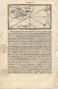 |
This item is licensed under a Creative Commons License
