DSpace CRIS
DSpace-CRIS consists of a data model describing objects of interest to Research and Development and a set of tools to manage the data. Standard DSpace is used to deal with publications and data sets, whereas DSpace-CRIS involves other CRIS entities: Researcher Pages, Projects, Organization Units and Second Level Dynamic Objects (single entities specialized by a profile, such as Journal, Prize, Event etc; because any profile can define its own set of properties and nested objects)
Learn MorePlease use this identifier to cite or link to this item:
https://hdl.handle.net/10316.2/43567| Title: | Chart of the Açores (Hawks) Islands, called also Flemish and Western Islands. | Keywords: | Açores;Oceano Atlântico;Carta náutica | Issue Date: | 1772 | Publisher: | Printed for Robert Sayer as the Act directs | Description: | Inclui perfis das ilhas e planos inseridos na carta e com as legendas. | URI: | https://hdl.handle.net/10316.2/43567 | Rights: | open access |
| Appears in Collections: | Cartografia |
Files in This Item:
| File | Description | Size | Format | |
|---|---|---|---|---|
| UCBG-NC-0990_0001_1_t0.tif | 159.68 MB | TIFF | 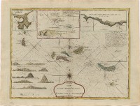 |
This item is licensed under a Creative Commons License
