DSpace CRIS
DSpace-CRIS consists of a data model describing objects of interest to Research and Development and a set of tools to manage the data. Standard DSpace is used to deal with publications and data sets, whereas DSpace-CRIS involves other CRIS entities: Researcher Pages, Projects, Organization Units and Second Level Dynamic Objects (single entities specialized by a profile, such as Journal, Prize, Event etc; because any profile can define its own set of properties and nested objects)
Learn MorePlease use this identifier to cite or link to this item:
https://hdl.handle.net/10316.2/43595| Title: | Höhen und Tiefen der Erde in Lambert's Zenithal Projection | Authors: | Berghaus, Hermann | Keywords: | Geografia mundial;Mapa | Issue Date: | 1879 | Publisher: | Justus Perthes | Description: | Publicado originalmente em: "Hand Atlas Uber Alle Theile Der Erde Und Uber Das Weltgebaude. Von Adolf Stieler. N{u00BA} 8. | URI: | https://hdl.handle.net/10316.2/43595 | Rights: | open access |
| Appears in Collections: | Cartografia |
Files in This Item:
| File | Description | Size | Format | |
|---|---|---|---|---|
| UCBG-NC-1044_0001_1_t0.tif | 65.35 MB | TIFF | 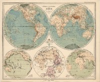 |
This item is licensed under a Creative Commons License
