DSpace CRIS
DSpace-CRIS consists of a data model describing objects of interest to Research and Development and a set of tools to manage the data. Standard DSpace is used to deal with publications and data sets, whereas DSpace-CRIS involves other CRIS entities: Researcher Pages, Projects, Organization Units and Second Level Dynamic Objects (single entities specialized by a profile, such as Journal, Prize, Event etc; because any profile can define its own set of properties and nested objects)
Learn MorePlease use this identifier to cite or link to this item:
https://hdl.handle.net/10316.2/43617| Title: | Spain and Portugal. A map of the mouth of the River Tagus or harbour of the city of Lisbon | Keywords: | Península Ibérica;Lisboa | Issue Date: | 1756 | Publisher: | [Sylvanus Urban] | Description: | Escala gráfica: 60 English Leagues 20 to Degree. | URI: | https://hdl.handle.net/10316.2/43617 | Rights: | open access |
| Appears in Collections: | Cartografia |
Files in This Item:
| File | Description | Size | Format | |
|---|---|---|---|---|
| UCBG-NC-0975_0001_1_t0.tif | 21.21 MB | TIFF | 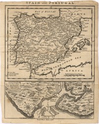 |
This item is licensed under a Creative Commons License
