DSpace CRIS
DSpace-CRIS consists of a data model describing objects of interest to Research and Development and a set of tools to manage the data. Standard DSpace is used to deal with publications and data sets, whereas DSpace-CRIS involves other CRIS entities: Researcher Pages, Projects, Organization Units and Second Level Dynamic Objects (single entities specialized by a profile, such as Journal, Prize, Event etc; because any profile can define its own set of properties and nested objects)
Learn MorePlease use this identifier to cite or link to this item:
https://hdl.handle.net/10316.2/43701| Title: | Mappa ou carta geographica dos reinos de Portugal e Algarve | Keywords: | Portugal | Issue Date: | 1762 | Publisher: | [s.n.] | Description: | Na margem inferior à esquerda apresenta cartela de titulo e cartela onde o autor dedica o mapa a John Earl of Bute : "To the Right Honourable John Earl of Bute, Viscount Kingarth, Baron Mountstuart, Cumbray and Inchmarnock; One of the Lords of His Majesty's most Honble. Privy Council, Knight of the most Antient e Most Noble Orders of the Thistle and Garter, and {u2026} "; as cartelas estão inseridas numa grande ilustração onde se destacam três figuras femininas representando Portugal e a Grâ-Bretanha. Margens graduadas. Apresenta notas explicativas da história e geografia do reino. Escala gráfica: 10 Legoas commuas de Portugal e d'Espanha 19. à hum Grao ; 40 Milhas Britannicas por Estatuto 69 1/2 à hum Grao ; 15 Legoas commuas de França 25 à hum Grao. |
URI: | https://hdl.handle.net/10316.2/43701 | Rights: | open access |
| Appears in Collections: | Cartografia |
Files in This Item:
| File | Description | Size | Format | |
|---|---|---|---|---|
| UCBG-NC-1224_0001_1_t0.tif | 228.38 MB | TIFF | 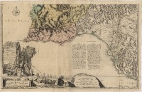 |
This item is licensed under a Creative Commons License
