DSpace CRIS
DSpace-CRIS consists of a data model describing objects of interest to Research and Development and a set of tools to manage the data. Standard DSpace is used to deal with publications and data sets, whereas DSpace-CRIS involves other CRIS entities: Researcher Pages, Projects, Organization Units and Second Level Dynamic Objects (single entities specialized by a profile, such as Journal, Prize, Event etc; because any profile can define its own set of properties and nested objects)
Learn MorePlease use this identifier to cite or link to this item:
https://hdl.handle.net/10316.2/43715| DC Field | Value | Language |
|---|---|---|
| dc.contributor.author | Bühler, S | - |
| dc.coverage.spatial | Escala não determinada | - |
| dc.date.accessioned | 2019-07-30T15:51:46Z | - |
| dc.date.available | 2019-07-30T15:51:46Z | - |
| dc.date.issued | 1850 | - |
| dc.identifier.uri | https://hdl.handle.net/10316.2/43715 | - |
| dc.description | Margem superior inscrito: "Thiers Consulat u. Kaiserreich" e "Karte n{u00BA} 53". | - |
| dc.description | Escala Gráfica: 10 Myriametres, 25 Meilen auf 1 Grad. | - |
| dc.format.extent | 1 mapa : p&b ; 32x29 cm | - |
| dc.format.mimetype | application/pdf | - |
| dc.format.mimetype | image/tiff | - |
| dc.language.iso | ger | - |
| dc.publisher | Verlag von J. Bensheimer | - |
| dc.rights | open access | - |
| dc.rights.uri | https://creativecommons.org/licenses/by/4.0 | - |
| dc.subject | Portugal | - |
| dc.title | Karte des theiles von Portugal zwischen dem Duero, Ocean uns Guadiana | ger |
| dc.type | map | - |
| uc.publication.location | Mannheim | - |
| dc.contributor.publisher | Bensheimer, J. | - |
| uc.publication.digCollection | BG | - |
| uc.publication.digCollection | NC | - |
| uc.publication.digLibrary | ucbg | - |
| uc.publication.manifest | https://dl.uc.pt/json/iiif/10316.2/43715/107286/manifest?manifest=/json/iiif/10316.2/43715/107286/manifest | - |
| uc.publication.thumbnail | https://dl.uc.pt/retrieve/5687903 | - |
| uc.publication.copynote | Material frágil, acesso sob autorização. | - |
| uc.publication.callnumber | NC-1219 | - |
| uc.publication.siib | b2722975 | - |
| uc.publication.images | 2 | |
| uc.publication.publisher | Mannheim : Verlag von J. Bensheimer, [c. 1850] | - |
| dc.subject.udc | 912 (469) "18" | - |
| uc.publication.subject | Portugal -- mapa -- séc. 19 | - |
| uc.contributor.authorView | Bühler, S | - |
| uc.contributor.publisherView | Bensheimer, J. | - |
| uc.publication.date | [c. 1850] | - |
| uc.itemId | 44978 | - |
| uc.thumbnail.uri | https://dl.uc.pt/iiif-imgsrv/5687729/dl!4!UC!BG!-N!UCBG-NC-1219_0001_1_t0.tif | - |
| item.grantfulltext | open | - |
| item.fulltext | With Fulltext | - |
| Appears in Collections: | Cartografia | |
Files in This Item:
| File | Description | Size | Format | |
|---|---|---|---|---|
| UCBG-NC-1219_0001_1_t0.tif | 49.53 MB | TIFF | 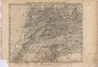 |
This item is licensed under a Creative Commons License
