DSpace CRIS
DSpace-CRIS consists of a data model describing objects of interest to Research and Development and a set of tools to manage the data. Standard DSpace is used to deal with publications and data sets, whereas DSpace-CRIS involves other CRIS entities: Researcher Pages, Projects, Organization Units and Second Level Dynamic Objects (single entities specialized by a profile, such as Journal, Prize, Event etc; because any profile can define its own set of properties and nested objects)
Learn MorePlease use this identifier to cite or link to this item:
https://hdl.handle.net/10316.2/43735| Title: | Map of the wine district of the Alto-Douro | Keywords: | Trás-os-Montes e Alto Douro;Mapa | Issue Date: | 1853 | Publisher: | Jonh Weale J. Menzies Continho |
Description: | Escala gráfica: 2 Geographick Leagues ; 2 Portuguese Leagues ; 5670 Braças ; 8 polegadas Actual Measure ; 9 Inches ; 22 centrimetros 10 Spanish Inches. | URI: | https://hdl.handle.net/10316.2/43735 | Rights: | open access |
| Appears in Collections: | Cartografia |
Files in This Item:
| File | Description | Size | Format | |
|---|---|---|---|---|
| UCBG-NC-1276_0001_1_t0.tif | 184.59 MB | TIFF | 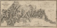 |
This item is licensed under a Creative Commons License
