DSpace CRIS
DSpace-CRIS consists of a data model describing objects of interest to Research and Development and a set of tools to manage the data. Standard DSpace is used to deal with publications and data sets, whereas DSpace-CRIS involves other CRIS entities: Researcher Pages, Projects, Organization Units and Second Level Dynamic Objects (single entities specialized by a profile, such as Journal, Prize, Event etc; because any profile can define its own set of properties and nested objects)
Learn MorePlease use this identifier to cite or link to this item:
https://hdl.handle.net/10316.2/43776| DC Field | Value | Language |
|---|---|---|
| dc.coverage.spatial | [ca. 1:75 000] | - |
| dc.date.accessioned | 2019-07-30T16:17:22Z | - |
| dc.date.available | 2019-07-30T16:17:22Z | - |
| dc.date.issued | 1808 | - |
| dc.identifier.uri | https://hdl.handle.net/10316.2/43776 | - |
| dc.description | A margem inferior contém insertos os seguintes mapas: "A View of the City of Ponta Delgada taken from the Anchorage, sbewing and Marks, as survyed June 10 th. 1806" - Escala ca 1:11000, determinada com o valor calculado 3,40 cm correspondente a "200 Fathoms" ingleses . - "The Mole e Castle of St. Braz" - Escala ca 1:3200, determinada com o valor calculado 2,90 cm correspondente a "50 Fathoms" ingleses . - "Plan of the Bason" - Escala ca 1:4700, determinada com o valor calculado 3,90 cm correspondente a "100 English Fathoms" . - "A Survey of Villa Franca with the adjacent Island" - Escala ca 1:9900, determinada com o valor calculado 1,85 cm correspondente a "100 Fathoms" ingleses. | - |
| dc.format.extent | 1 mapa : p&b ; 63x92 cm | - |
| dc.format.mimetype | application/pdf | - |
| dc.format.mimetype | image/tiff | - |
| dc.language.iso | eng | - |
| dc.publisher | Published as the Act Directs by William Heather | - |
| dc.rights | open access | - |
| dc.rights.uri | https://creativecommons.org/licenses/by/4.0 | - |
| dc.subject | Ilha de São Miguel (Açores) | - |
| dc.title | Chart of the Island of St. Michael | eng |
| dc.type | map | - |
| uc.publication.location | Londres | - |
| uc.publication.digCollection | BG | - |
| uc.publication.digCollection | NC | - |
| uc.publication.digLibrary | ucbg | - |
| uc.publication.manifest | https://dl.uc.pt/json/iiif/10316.2/43776/107433/manifest?manifest=/json/iiif/10316.2/43776/107433/manifest | - |
| uc.publication.thumbnail | https://dl.uc.pt/retrieve/5712158 | - |
| uc.publication.callnumber | NC-1435 | - |
| uc.publication.siib | b2723243 | - |
| uc.publication.images | 2 | - |
| uc.publication.publisher | London : Published as the Act Directs by William Heather, 1808 | - |
| dc.subject.udc | 912 (469.9) "18" | - |
| uc.publication.subject | Ilha de São Miguel -- mapa -- 1808 | - |
| dc.contributor.engraver | Stephenson, John | - |
| dc.contributor.cartographer | Read, W. Harding | - |
| uc.contributor.engraverView | Stephenson, John, fl. 1786-1800 | - |
| uc.publication.date | 1808 | - |
| uc.contributor.cartographerView | Read, W. Harding | - |
| uc.itemId | 45039 | - |
| uc.thumbnail.uri | https://dl.uc.pt/iiif-imgsrv/5688132/dl!4!UC!BG!-N!UCBG-NC-1435_0001_1_t0.tif | - |
| item.grantfulltext | open | - |
| item.fulltext | With Fulltext | - |
| Appears in Collections: | Cartografia | |
Files in This Item:
| File | Description | Size | Format | |
|---|---|---|---|---|
| UCBG-NC-1435_0001_1_t0.tif | 287.99 MB | TIFF | 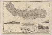 |
This item is licensed under a Creative Commons License
