DSpace CRIS
DSpace-CRIS consists of a data model describing objects of interest to Research and Development and a set of tools to manage the data. Standard DSpace is used to deal with publications and data sets, whereas DSpace-CRIS involves other CRIS entities: Researcher Pages, Projects, Organization Units and Second Level Dynamic Objects (single entities specialized by a profile, such as Journal, Prize, Event etc; because any profile can define its own set of properties and nested objects)
Learn MorePlease use this identifier to cite or link to this item:
https://hdl.handle.net/10316.2/43850| Title: | A topographical chart of the entrance of the river Tagus, describing the coast from Cape Roca to Sacavem ; with the harbour and environs of Lisbon. The nautical part is from a survey taken in 1806 by W. Chapman, Master of the Royal Navy; and approved by the Chart Committee of the Admiralty. The interior and line of the coast are drawn from survays made by officers of the Quarter Master General's Department | Authors: | Chapman, William | Keywords: | Rio Tejo;Carta náutica | Issue Date: | 1810 | Publisher: | published by W. Faden geographer to His Majesty e to His Royal Highness the prince of Wales | Description: | Incluso vistas: "The Rock of lisbon, Cape Espitchel, Belem Castle e South Channel" Publicado juntamente com mais dois mapas em caixa denominada Spain. / published by W. Faden. |
URI: | https://hdl.handle.net/10316.2/43850 | Rights: | open access |
| Appears in Collections: | Cartografia |
Files in This Item:
| File | Description | Size | Format | |
|---|---|---|---|---|
| UCBG-NC-0930_0001_1_t0.tif | 255.64 MB | TIFF | 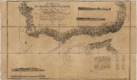 |
This item is licensed under a Creative Commons License
