DSpace CRIS
DSpace-CRIS consists of a data model describing objects of interest to Research and Development and a set of tools to manage the data. Standard DSpace is used to deal with publications and data sets, whereas DSpace-CRIS involves other CRIS entities: Researcher Pages, Projects, Organization Units and Second Level Dynamic Objects (single entities specialized by a profile, such as Journal, Prize, Event etc; because any profile can define its own set of properties and nested objects)
Learn MorePlease use this identifier to cite or link to this item:
https://hdl.handle.net/10316.2/43851| Title: | A new map of Spain and Portugal : exhibiting the chains of mountains with their passes, the principal & cross roads, with other details requisite for the intelligence of Military Operations | Keywords: | Peninsula Ibérica;Mapa | Issue Date: | 1810 | Publisher: | published by W. Faden geographer to His Majesty e to His Royal Highness the prince of Wales | Description: | Publicado juntamente com mais dois mapas em caixa denominada Spain. / published by W. Faden. Margens graduadas. Escala gráfica: Geographic or nautic miles, 60 to a degree ; 20 Spanish Leagues of 1572 Varas 17 1/2 to a degree ; 35 Castillan legal Leagues of 5000 Varas , 26 1/2 to a degree; 25 Portuguese Leagues, 19 to a degree ; 70 British Miles of 1760 yards, about 69 1/2 to a degree ; 20 Common French Leagues of 2282 Toises, 25 to a degree. |
URI: | https://hdl.handle.net/10316.2/43851 | Rights: | open access |
| Appears in Collections: | Teste - Nabais Conde reprocessados |
Files in This Item:
| File | Description | Size | Format | |
|---|---|---|---|---|
| UCBG-NC-0932_0001_1_t0.tif | 193.03 MB | TIFF | 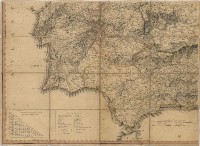 |
This item is licensed under a Creative Commons License
