DSpace CRIS
DSpace-CRIS consists of a data model describing objects of interest to Research and Development and a set of tools to manage the data. Standard DSpace is used to deal with publications and data sets, whereas DSpace-CRIS involves other CRIS entities: Researcher Pages, Projects, Organization Units and Second Level Dynamic Objects (single entities specialized by a profile, such as Journal, Prize, Event etc; because any profile can define its own set of properties and nested objects)
Learn MorePlease use this identifier to cite or link to this item:
https://hdl.handle.net/10316.2/72739| Title: | [A Map of the Principal Triangles of the Geodetical Operations of Portugal] | Authors: | Ciera, Francisco António | Issue Date: | 1805 | Publisher: | A. Arrowsmith | URI: | https://hdl.handle.net/10316.2/72739 | Rights: | open access |
| Appears in Collections: | Cartografia |
Files in This Item:
| File | Description | Size | Format | |
|---|---|---|---|---|
| UCSIB-G3a_0001_1_t0.tif | 1 | 103 MB | TIFF | 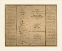 |
This item is licensed under a Creative Commons License
