DSpace CRIS
DSpace-CRIS consists of a data model describing objects of interest to Research and Development and a set of tools to manage the data. Standard DSpace is used to deal with publications and data sets, whereas DSpace-CRIS involves other CRIS entities: Researcher Pages, Projects, Organization Units and Second Level Dynamic Objects (single entities specialized by a profile, such as Journal, Prize, Event etc; because any profile can define its own set of properties and nested objects)
Learn MorePlease use this identifier to cite or link to this item:
https://hdl.handle.net/10316.2/43776| Title: | Chart of the Island of St. Michael | Keywords: | Ilha de São Miguel (Açores) | Issue Date: | 1808 | Publisher: | Published as the Act Directs by William Heather | Description: | A margem inferior contém insertos os seguintes mapas: "A View of the City of Ponta Delgada taken from the Anchorage, sbewing and Marks, as survyed June 10 th. 1806" - Escala ca 1:11000, determinada com o valor calculado 3,40 cm correspondente a "200 Fathoms" ingleses . - "The Mole e Castle of St. Braz" - Escala ca 1:3200, determinada com o valor calculado 2,90 cm correspondente a "50 Fathoms" ingleses . - "Plan of the Bason" - Escala ca 1:4700, determinada com o valor calculado 3,90 cm correspondente a "100 English Fathoms" . - "A Survey of Villa Franca with the adjacent Island" - Escala ca 1:9900, determinada com o valor calculado 1,85 cm correspondente a "100 Fathoms" ingleses. | URI: | https://hdl.handle.net/10316.2/43776 | Rights: | open access |
| Appears in Collections: | Cartografia |
Files in This Item:
| File | Description | Size | Format | |
|---|---|---|---|---|
| UCBG-NC-1435_0001_1_t0.tif | 287.99 MB | TIFF | 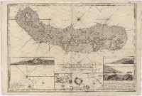 |
This item is licensed under a Creative Commons License
